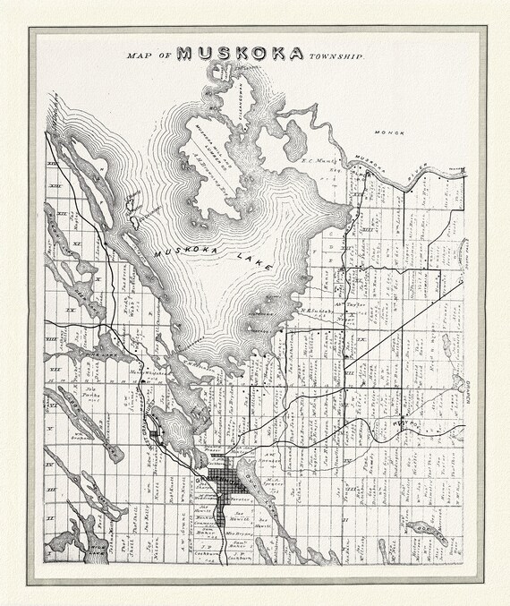
 Muskoka Township, 1893, map on heavy cotton canvas, 22x27" approx.
$40.18
Muskoka Township, 1893, map on heavy cotton canvas, 22x27" approx.
$40.18
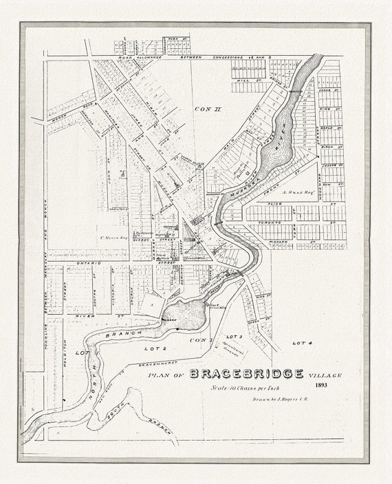 Bracebridge, Muskoka Region, 1893, map on heavy cotton canvas, 22x27" approx.
$40.18
Bracebridge, Muskoka Region, 1893, map on heavy cotton canvas, 22x27" approx.
$40.18
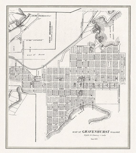 Gravenhurst Village, Muskoka, 1893,map on heavy cotton canvas, 22x27" approx.
$40.18
Gravenhurst Village, Muskoka, 1893,map on heavy cotton canvas, 22x27" approx.
$40.18
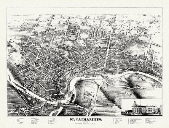 St. Catharines, Ont., A birdseye View, 1878, map on durable cotton canvas, 50 x 70 cm, 20 x 25" approx.
$40.18
St. Catharines, Ont., A birdseye View, 1878, map on durable cotton canvas, 50 x 70 cm, 20 x 25" approx.
$40.18
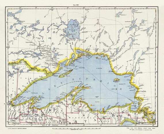 Letts, North Shore, Lake Superior, Canada,1883, Map on heavy cotton canvas, 22x27" approx.
$40.18
Letts, North Shore, Lake Superior, Canada,1883, Map on heavy cotton canvas, 22x27" approx.
$40.18
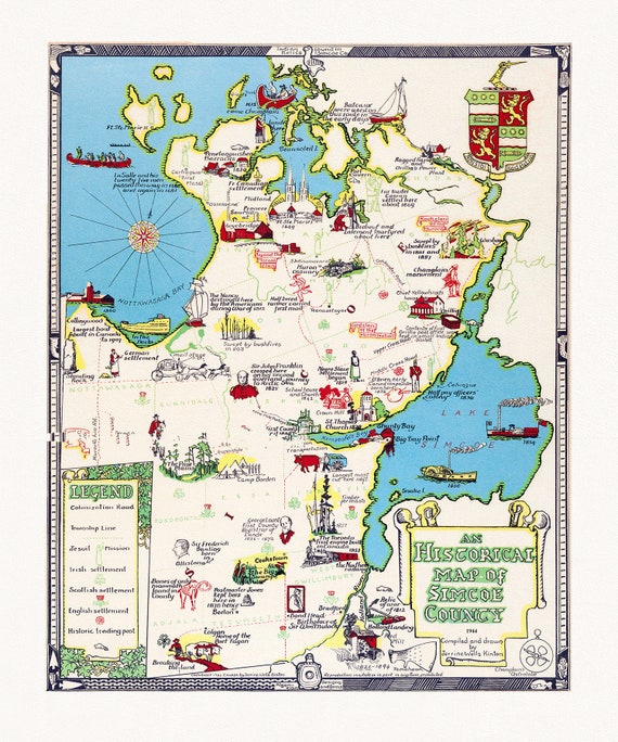 An historical map of Simcoe County, Ontario, 1944, map on heavy cotton canvas, 22x27" approx.
$40.18
An historical map of Simcoe County, Ontario, 1944, map on heavy cotton canvas, 22x27" approx.
$40.18
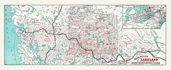
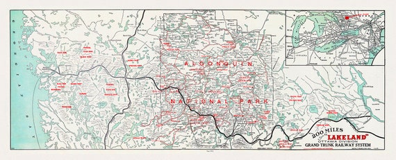 Historic Algonquin Park Map, Grand Trunk Railway, 1912, map on heavy cotton canvas, 22x27" approx.
$40.18
Historic Algonquin Park Map, Grand Trunk Railway, 1912, map on heavy cotton canvas, 22x27" approx.
$40.18
 Algonquin-Haliburton: Grand Trunk Railway, Historic Algonquin Park Map, 1906, map on heavy cotton canvas, 22x27" approx.
$40.18
Algonquin-Haliburton: Grand Trunk Railway, Historic Algonquin Park Map, 1906, map on heavy cotton canvas, 22x27" approx.
$40.18
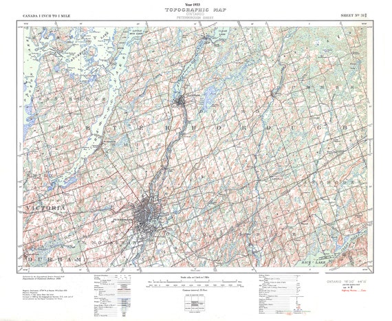 Peterborough, Ont. Topographic Map sheet 031D08, 1933 , map on durable cotton canvas, 50 x 70 cm, 20 x 25" approx.
$40.18
Peterborough, Ont. Topographic Map sheet 031D08, 1933 , map on durable cotton canvas, 50 x 70 cm, 20 x 25" approx.
$40.18
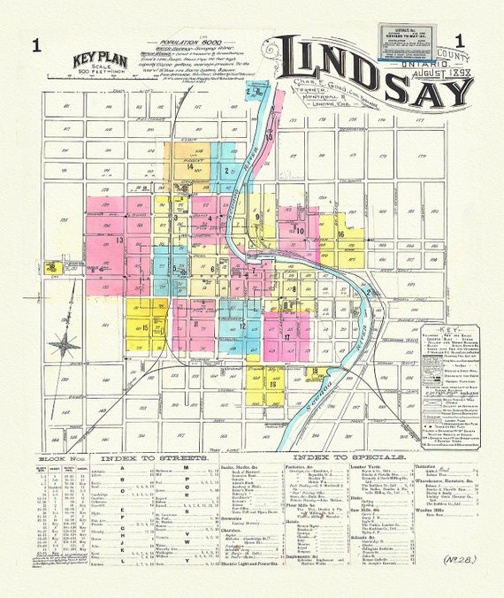 Key Plan, Lindsay, Ontario, 1898 , map on durable cotton canvas, 50 x 70 cm, 20 x 25" approx.
$40.18
Key Plan, Lindsay, Ontario, 1898 , map on durable cotton canvas, 50 x 70 cm, 20 x 25" approx.
$40.18
 Historic Algonquin Park Map, Grand Trunk Railway, 1912, map on heavy cotton canvas, 22x27" approx.
$40.18
Historic Algonquin Park Map, Grand Trunk Railway, 1912, map on heavy cotton canvas, 22x27" approx.
$40.18
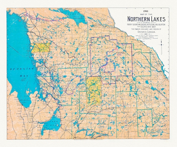 Muskoka-Haliburton: Map of the Northern Lakes, 1901, map on heavy cotton canvas, 22x27" approx.
$40.18
Muskoka-Haliburton: Map of the Northern Lakes, 1901, map on heavy cotton canvas, 22x27" approx.
$40.18
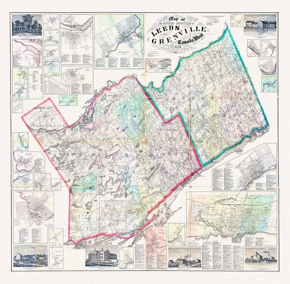 Map of the United Counties of Leeds and Grenville, Canada West.1861, map on durable cotton canvas, 50 x 70 cm, 20 x 25" approx.
$40.18
Map of the United Counties of Leeds and Grenville, Canada West.1861, map on durable cotton canvas, 50 x 70 cm, 20 x 25" approx.
$40.18
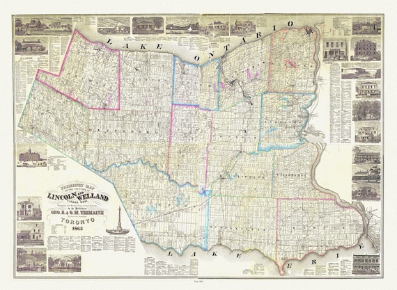 Wellend & Lincoln Counties, Treamaine auth., 1862, map on durable cotton canvas, 50 x 70 cm, 20 x 25" approx.
$40.18
Wellend & Lincoln Counties, Treamaine auth., 1862, map on durable cotton canvas, 50 x 70 cm, 20 x 25" approx.
$40.18
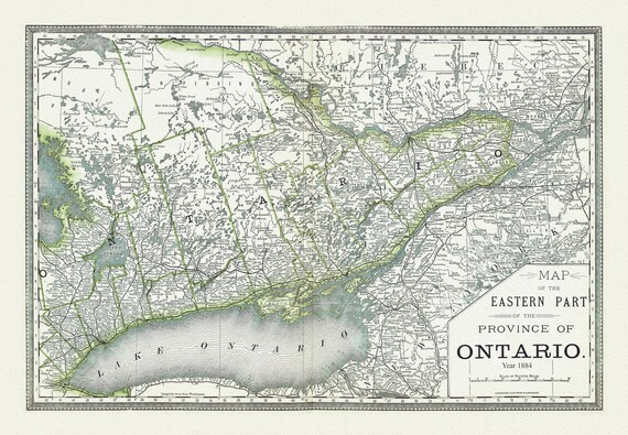 H.H. Hardesty & Co., Map of Ontario, No. 2, Eastern Part, 1884, map on heavy cotton canvas, 22x27" approx
$40.18
H.H. Hardesty & Co., Map of Ontario, No. 2, Eastern Part, 1884, map on heavy cotton canvas, 22x27" approx
$40.18
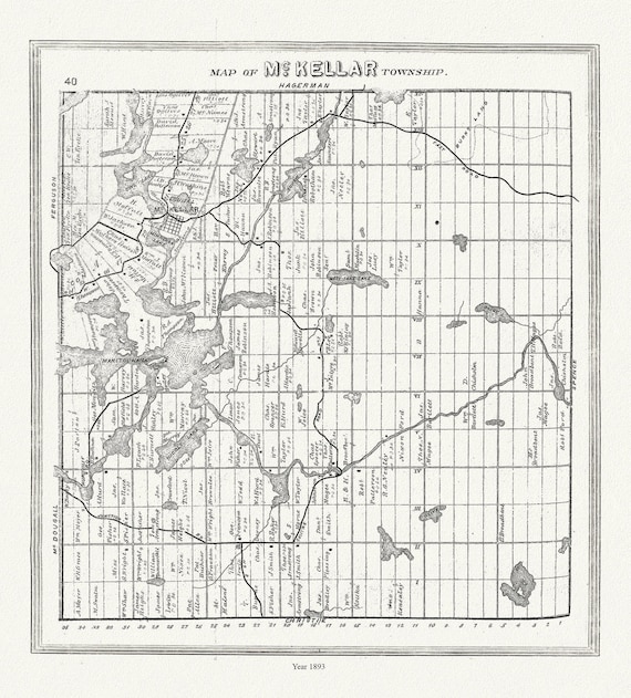 Muskoka-Haliburton, McKellar Township, 1893, map on heavy cotton canvas, 20 x 25" approx.
$40.18
Muskoka-Haliburton, McKellar Township, 1893, map on heavy cotton canvas, 20 x 25" approx.
$40.18
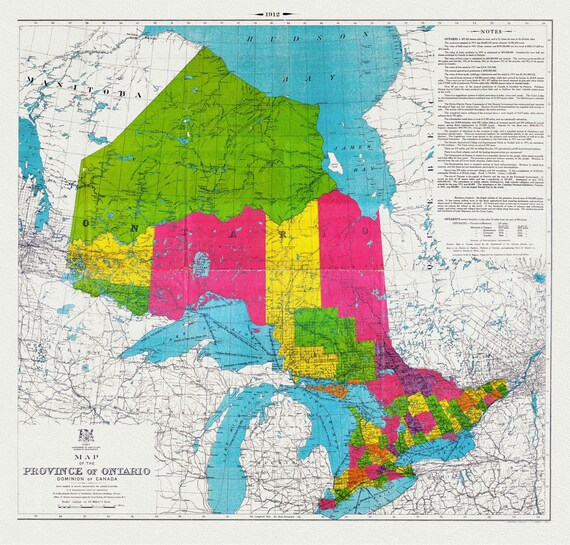 Map of the Province of Ontario, Dominion of Canada, 1912, map on heavy cotton canvas, 22x27" approx.
$40.18
Map of the Province of Ontario, Dominion of Canada, 1912, map on heavy cotton canvas, 22x27" approx.
$40.18
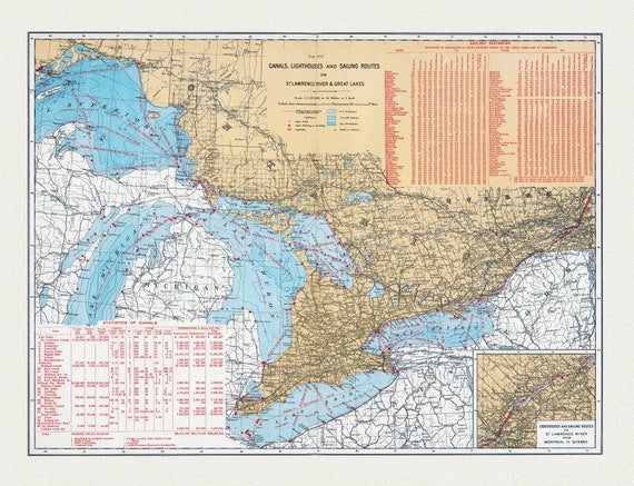 Department of the Interior, Canals, Lighthouses and sailing routes on St. Lawrence River & Great Lakes, 1915, cotton canvas, 22x27" approx.
$40.18
Department of the Interior, Canals, Lighthouses and sailing routes on St. Lawrence River & Great Lakes, 1915, cotton canvas, 22x27" approx.
$40.18
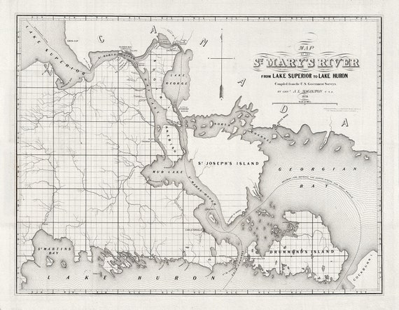 St. Mary's River From Lake Superior To Lake Huron, Ontario, Map on heavy Cotton Canvas, 1855, 22x27" approx.
$40.18
St. Mary's River From Lake Superior To Lake Huron, Ontario, Map on heavy Cotton Canvas, 1855, 22x27" approx.
$40.18
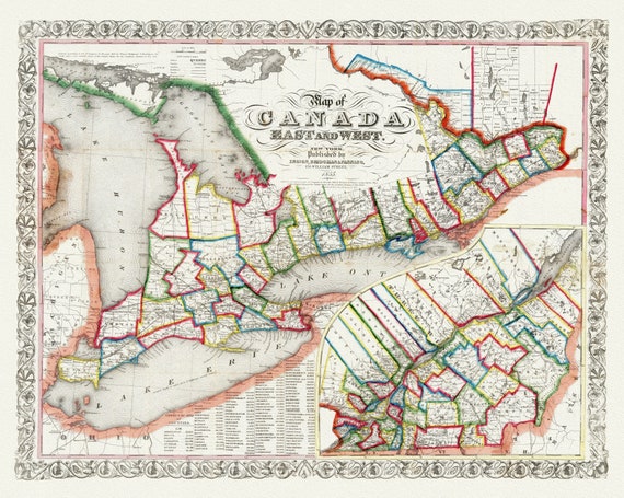 Ensign, Bridgman & Fanning, A Map of Canada East And West, 1855, map on heavy cotton canvas, 22x27" approx.
$40.18
Ensign, Bridgman & Fanning, A Map of Canada East And West, 1855, map on heavy cotton canvas, 22x27" approx.
$40.18